 Options
MogTrails is a mobile phone application to create GPS tracks in the GPX format. It connects to a GPS device over bluetooth and monitors the positioning information. Based upon this data a log-file is written on the phone storing positions along your way. MogTrails is free to use and hopefully soon the source will be free as well.
|
Track Examples |
MogTrails is specifically designed to support photographers interested in GeoTagging their photos, i.e. associate a photo with a position. To use this software you need both a mobile phone and a Bluetooth GPS. I use Holux GPSlim236 which you can buy quite cheap from Nav4All, about 70€.
Check out the version history to see what has changed between releases.
The application is very simple and basically has just two different screens, either Options or Status. The later show the current progress in collecting positions and writing these to a GPX log file. Under Options you can configure the behaviour of the application. When you start the application if no GPS device is set the user will be presented with the Options screen, if there is a GPS device stored from a previous session the Status screen will be presented.
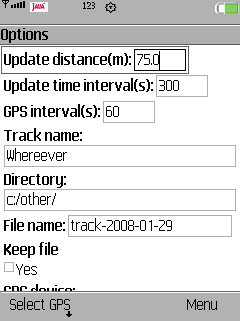
OptionsThrough a number of options you can control how the application behaves, among other things how and what data is stored into the log file. The different options are explained below. To set this options edit respectively in the first screen that appear when you start MogTrails.
There are two options that control how often new positioning information is stored in the log file. You can control this either by the amount of time or distance passed.
Update distance is the distance you have to travel before a new position is stored into the log-file.
Update time interval is the amount of time that has to pass before a new position is stored into the log-file. Either of these two that occurs first will cause a position to be stored in the file.
These two options can be used for instance if you know that you will walk around for a day and stay at a few places and spend quite some time at each. By setting the update distance to about 150 m and the update time interval to 15 minutes you will still have a quite small log file but the positioning information will still be quite accurate.
A good rule of thumb for the update distance is that at normal walking speed(4 km/h) one will travel approximately 67m in 60 seconds.
GPS interval controls how often the application will communicate with your GPS unit. This is mainly a feature to spare some battery power of the GPS since it will only take about 5 seconds to get enough information from the unit to make a position entry into the log-file. If set to 0 the application will never disconnect from the GPS as long as it is in Bluetooth range.
Track name is a name you can give the track stored in the log-file. It is also possible to change this during run-time, once the data collection is started. For instance, you can change name of the track once you get up from the subway after changing place.
Directory is where the log-file will be stored. The default value c:/other will on SonyEricsson phones store the file in the Other folder in the phone memory.
File name is the name of the actual log-file. It will be stored in the directory indicated with the Directory options. The application will also add a suffix to the file, .gpx. Furthermore it will suggest filename based upon today's date e.g. "track-YYYY-MM-DD.gpx". If the Keep file options is not checked and the file already exists it will try to create a new file instead with a sequence number added at the end of the file name e.g. "track-2007-07-12-2.gpx"
Keep file controls if a new file should be created or not if an existing file is detected. If checked MogTrails will continue to write to the old file.
GPS device is the name of the currently selected GPS device. To select a GPS you have to select the command "Select GPS", see Scanning below.
Once you have altered the options to your liking, select the command "Set" to get to the Status view. With the "Exit" command you can always quit the application, and "Help" will present a short version of this text. The "Cancel" command will restore all values to what they were before you activated Options.
If you select the command "Select GPS" you will be presented with the Scanning view. Here you can scan for Bluetooth devices in your proximity and select the one you would like MogTrails to communicate with. There are four different commands to chose from:
"Help" will present a simple help text.
"Exit" will quit the whole application.
"Cancel" will return you to the Options view.
"Start" will start a scan for Bluetooth devices. Once finished it will present you with a list of choices and you can Choose one.By choosing a device you will be brought back to the Options view.
 Status
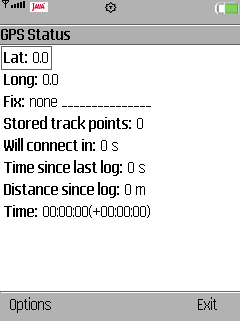
The Status view helps you monitor the tracking. Lat respectively Long are the last received latitude and longitude from the GPS, n.b. this does not mean these are stored into the file! Fix indicates how good reception your GPS currently has(None, 2D or 3D) or "GPS unavailable" if the application cannot communicate with the GPS at all. Stored track points indicate the number of position points that has been stored into the log-file. Will connect in tells you how many seconds left until the application will try to connect to your GPS device. Time since last log is the amount of seconds since a position was stored into the log-file and Distance since last log is how far we have traveled since the last log entry. And finally the last row, Time:, indicates the GPS clock. Since data from the GPS is only sampled at certain intervals, the time showed here is an interpolation between those samples. Basically, this clock gets synchronized each time new data is received from the GPS. The time within the parentheses is the time difference between the clock in the GPS and the phone. Can be useful if you use the camera in the phone, then you will know if that your images will be slightly offset due to this time difference.
The "Start" command will tell the application to connect to your GPS and start storing positions into the log-file. Up until you select "Start" you can change the log-filename though once started it will stay the same until you exit. You can activate the Options view again by selecting the "Options" command. Here you can change everything except the log-filename if you have started to record into the file. "Exit" will terminate the application.
The latest release is available to download here.
Currently there is only one way to install MogTrails and that is to copy both the jad and jar-file to the phone. The following steps are for a SonyEricsson phone.
Open the Sony Ericsson File Manager on your PC, open up you phone, browse to Phone memory/Other directory.
Copy the MogTrails.jad and MogTrails.jar file into this directory.
On your phone, open up the File Manager and browse into the Other directory. There you will find to Java files called MogTrails and you can select Install for both. Select the topmost one to install. If you are a bit unsure if it is the correct one, select More when you have the file highlighted. Select Information at the bottom of the menu. If it is the correct file the File type: should be jad.
Install MogTrails and select to save it in Applications or Games. Do not start it now!
With the File Manager on the phone, browse into the folder where you installed MogTrails(Games or Application).
Highlight MogTrails and press More and select Permissions. In Local connectivity, Read user data and Write user date mark "Never ask". This will help you quite a lot, because if you do not do this, you will be asked each time the application is going to store data into the log-file if you want to allow that.
Now you can start using MogTrails. Good luck!
MogTrails is developed on my spare time so I cannot provide professional support but I'll try to do my best. If you run into some problems or oddities please contact me at
Current version of MogTrails generates also some log-files which can help me to track problems. They are called mogtrails.log or similar. These are debug files, debug messages from the software is written there. So if you experience a crash or similar you can send that file to me and I will hopefully be able to tell what went wrong. Each file will never get bigger than 1Mb and there will never be more than 5 debug log files so as long as you have more than 5Mb free there will not be any risk of running out of memory due to the log files. Though if this is an issue on your phone, contact me and I'll create a release without this logging functionality.
I'm very interested in all
kind of feedback and suggestions. Please use the same support e-mail address to send
those. Also please if any
thing is unclear or confusing, let me know and I'll help out.
MogTrails should run on any Java compatible phone with JSR-82 and JSR-75. How will you know? Best is to check the web site for you phone, and if both of those are listed, it is very likely MogTrails will work. So far I have not been able to properly test MogTrails on Nokia phones. First I have had problems in setting up the emulators and secondly I do not own a Nokia. So if you are interested in helping out debugging MogTrails on a Nokia, please contact me.
Mobile phones
SonyEricsson K800
GPS units
Holux GPSlim236
At the moment no know bugs are known. Though on SonyEricsson K800 with firmware version R1CB001 sometimes the whole application becomes unresponsive. The timer "Time since last log" will keep on counting but you will see that the timer "Will connect in" will freeze at zero. Have not received any reports on this problem on any other device or firmware version.
Here is a list of features that might be included in future releases of MogTrails.