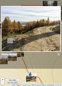
An example from the 10 km track.
Friends in the village organise the Åre Trail competition. They needed a better way to explain the track for their participants. I’m working on creating a Lightroom plugin to generate web based hiking stories and realised it could be easily modified to create a nice presentation of the track. Spent some time over the weekend to get photos and yesterday to finalise it.
The page shows a map with a GPS recording of the track. Along the track photos are placed at the different junctions where it might be a bit hard to find the trail. Clicking on a photo shows a larger version of the same photo overlaid on the map. If the users clicks the left or right arrow to go to the next photo/junction the map and the small figure is moved to that position as well.
Give it a try over at http://aretrail.com/mellan/